This and That Newsletter
www.OklahomaHistory.net
Vol 24 Issue 1,204 Circulation 5,000 February 20, 2020
Ardmore, Oklahoma
My permanent email address: butchbridges@oklahomahistory.net
580-490-6823
This newsletter, for the first time in many many years, is a day late. I had problems configuring my online mailing program I've been using for years, so I switched to another online free service. Hope this one reaches everyone ok.
A SHALLOW GRAVE & A RED RAG AROUND A DEAD WOMAN’S HEAD
When I was an Assistant D.A., I covered Johnson County, Tishomingo the county seat.
One morning, I received a call from the Sheriff asking me for assistance. When I arrived, he told me a rather bizarre story.
“Ada police is holding a 16-year old full blood female who swears her stepfather murdered her mother. We need to go bring her back.”
So, we drove to Ada, got the teen and drove back to Tishomingo since she didn’t want to be taken to Filmore, where she had lived with her mom, her 4 little brothers and her stepdad.
As we got out of the car, she said: “I can take you where my mom is buried.” Startled, I asked: “How do you know where she’s buried?” She said, “Because my stepdad threatened to bury me there.”
So, the 4 of us, including a 65-year old deputy named Dan, drove to Filmore & the house. We followed the teen to about 1,000 feet to a spot East of the house & there, at a spot in a clearing, she said: “There! That’s where my mom is buried.” (There was no indication whatsoever that the ground had been disturbed, but the Sheriff & I started carefully digging with our hands, since we hadn’t brought shovels).
About 3-4 inches below the surface of the ground, the Sheriff suddenly found remains of a red rag tied around some hair on the top of a human head.
The teen said, “There, that’s my mom; she always wore that hankie around her head.”
We went to the Sheriff’s vehicle, where he called the department in Tish & requested some help and some shovels. While we waited, I asked the teen: “Where’s your dad?” She said, “don’t know. He left with the 4-year old boy when I told him I was leaving to go to Ada to live with my aunt.”
The men arrived & started carefully digging & sure enough, the body of an Indian woman appeared. (Later, the ME found a tiny man’s belt around her neck. She had been strangled.)
She was buried on her all fours and her head and upper back and shoulders were mere inches from the surface of the ground. I asked the teen, “how long has your mom been here?” She said, “Several days, I’ve been gone over a week.” That concerned me since just looking at the body, one could tell it was rapidly decomposing. The odor coming from the now open grave was sickening.
I looked at the elderly deputy, standing near the now open grave. He was white as a sheet. I started to tell him to leave when suddenly he became dizzy, lurched toward the grave & lost his balance, stepping right in the middle of the lower back of the dead woman before falling over her.
That caused the contents of her stomach, lower intestines and Lord knows what else to literally explode out of the woman’s rear orifices. I grabbed Dan & hauled him away, then I emptied my stomach on the ground with some eruptions of vomit.
The dad & the 4-year old boy eluded searchers in the woods for 16 days before he was captured. I prosecuted him & a Johnson County jury gave him 44 years. He served 12, got paroled & died several years later.
The teen & her siblings moved to Ada where they lived with their aunt, who took great care of them. I checked on them occasionally and was satisfied they were okay.
Dan, the deputy who had stepped on the body, retired the day after we got back to Tish. He lived ten years or so & when I checked on him, he seemed okay. We never discussed that day at the gravesite. He was a good man and should have stayed home that day. -submitted by James Clark
A Glimpse into the Past
Arbuckle Mountains
Along the northern border of Carter County, lies a beautiful small mountain range known as the Arbuckle Mountains. The range is sixty miles long and twenty miles wide, lying in portions of several counties. lt is unusual in that the range runs east and west, which is a very rare finding among mountains. The mountains were named for General Matthew Arbuckle, who established Fort Gibson and Fort Towson.These mountains are widely known for their unusual geological formations, and are visited extensively by students and researchers. The rocky layers are exposed for study and are arranged in unusual patterns, one of which is long rows of jagged points running parallel to each other.
The Washita River cuts a deep gorge through the mountains, and Honey Creek forms the spectacular Turner Falls, one of the most beautiful scenes in the Southwest. The highest peak is only 1,400 feet above sea level. The eastern end of the range encompasses the unique Chickasaw National Recreation Area, with sulphur springs and bromide springs, which are widely used for health purposes. The new Lake of the Arbuckles is heavily used, as are other areas, for camping and recreation.
Carter Countians and other area residents feel very fortunate to live next to one of nature's beauty spots.
CRINER HILLS
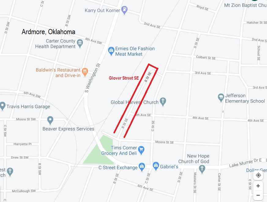
A small group of hills just southwest of Ardmore is known as Criner Hills. They were named from the earliest resident of the hills, John B. Criner. John was born in Sherman, Texas, in 1850, and the family moved in 1860 to Indian Territory. John made the hills his headquarters for various ranches he operated at Thackerville, Tatums, and Brock. John Criner was one of the first settlers south of the Arbuckles, and lived for 98 years, witnessing the tremendous growth of the area he pioneered. He died at his home in the Criner Hills in July, 1948. -Indian Territory and Carter County Pioneers book 1982In Ardmore "B" Street SE intersects Moore SE. In 1924 this two block section of "B" was called Glover SE. In 1924 where Glover SE intersected with Moore SE, was another street called London Street. London SE went off to the SE from Moore at an angle.
http://www.oklahomahistory.net/maps/GloverStreetSEArdmoreMap.jpg
Q. Where in Oklahoma are bodies including two U.S. Marshals buried under a multi purpose arena and indoor events center?
A. The BOK Center in Tulsa. From 1882 until 1905, Oklahomans buried approximately 300 bodies in the cemetery located on the land where the current BOK center sits. From 1882 until 1905, over 300 bodies were buried in the area that was known as Tulsa's first public cemetery. And before that, many people think it was an American Indian burial ground. CLICK HEREQ. Where in Oklahoma is the first and only casino and indoor water park?
A. Answer in next week's newsletterBelow is from This and That newsletter archives of February 21, 2008
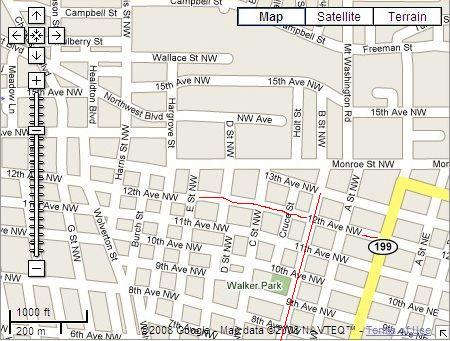
Last week Al Cullum of Overbrook stopped by. I never know what history he will have to share but I always smile when he walks in because I know its going to be worth the visit. Al asked me if I ever heard of Snuff Street in Ardmore. I was born and raised here and never heard of such a street. Al explained: Back in the 50s Al and his friends called the stretch of street between E Street NW and North Washington along 12th street, Snuff Street. During that period of time there were big dips in 12th street at every intersection. He said you would go a block, and take a dip, go another block, and take a dip. Al said if you were going too fast, your head would even hit the roof of your car when you took one of those dips. So now we all know about Snuff Street of the 40s and 50s in Ardmore, Oklahoma. Thanks Al.
http://www.oklahomahistory.net/ttphotos8a/SnuffStreet.jpghttp://www.oklahomahistory.net/ttphotos8a/AlbertCullumCard.jpg
---------------------------------------------------------------------
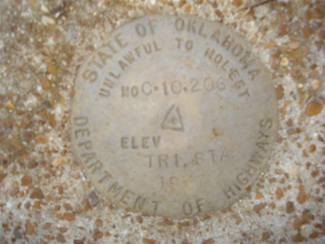
Last week I had a photo Doug Williams took of a geo marker he found on this newly acquired land east of Ardmore. I was swamped with emails from so many of you trying to help with identifying this State of Oklahoma marker. I will let Mike Carr, a local surveyor (and former county surveyor many moons ago) tell us in his own words:"Butch, This is your old surveyor friend Michael D. Carr. The Brass Monument C-10-206 is a monument set by the Oklahoma State Department of Highways for the purpose of Horizontal Control. This particular monument was set in 1977. These monuments that have Tri-Station on them are generally set on hill tops where it can be visible with other monuments usually only a mile or two radius depending on the relative terrain. C-10 designates Carter County - 206 is the number of the monument in numerical order. The ODOT also sets these type monuments for Section Corners, 1/4 Section Corners, and Bench Mark Positions. Bench Marks generally deal with vertical control-ie a point relative to Mean Sea Level. ODOT can give you copies of the control Data by calling the Survey Division at 405-521-2621. Generally you would ask for Waymon Gissandaner, but I just talked to him yesterday, and he is in St. Anthony Hospital suffering from a collapsed lung. Waymon is a prince among all land surveyors as he is always so polite and helpful with us in sending current or historical land data when we are performing surveys relative to Highway locations. Other Government agencies also set Brass Monuments for Horizontal and Vertical Control. Older Brass Monuments that can be found in our area may have USGS, Oklahoma Consevation Commission, Corps of Engineers (these are older government agency names). Newer monuments are being set all the time by NOAA, ODOT, and in Ardmore a complete control set data for development of all properties and tying them to the same relative coordinate system. The City of Ardmore has a GIS (Government Information System) coordinator, Charles Brady, who on a regular basis establishes relative positions of all types of ground facilities whether it be roads, trails, pipelines, or all the various utilities. We are slowly but surely becoming a "star-trek" society in that all of the newer controls are based on satellite configurations. You may have yourself a small hand held GIS tracking instrument. Groups are playing games with them all the time now - sort of-a long range type of scavenger hunt. Fun and games but the high price of gasoline now makes it a pretty expensive hobby; however the small hand held GIS instruments can be bought for as little as a hundred dollars to thousands of dollars. They tell you at the touch of your fingers your relative position on a global basis, giving you latitude-longitude, vertical as well as relative speed if you are moving. The accuracy of the hand held units are generally not more precise than ?25 or 30 feet. Hope this helps." -Michael D. Carr
http://www.oklahomahistory.net/ttphotos8a/WilliamsGeoMarker.jpg
---------------------------------------------------------------------
"Butch--loved the Pete and Repeat picture and how kind of Jill and you to put the basket out so they have a nice place to sleep. Many years ago (about 70 yrs) my mother and dad and I moved to Chandler, Oklahoma where I was in 3rd grade, each morning a black and white bull dog walked up the hill back of our house and waited til he was invited in for breakfast. My dad called him Major in honor of some former boss of his who apparently had bull dog tenacity in all his plans. I think we lived there for about three years and Major never missed a morning showing up for his breakfast. When we moved to another house I used to worry and cry about Major, I pictured him sitting at the back door waiting to be invited to breakfast. I still hope he was invited in by whoever the new occupants were. As always, I love all your newsletters----you are rendering a true service to all us Oklahomans who have moved away but left our hearts behind." -sammie
-------------------------------------------------------------------------
"Butch, It's now called Long Island rather than New York Island."
-------------------------------------------------------------------------
"Hi Butch, I was thinking back to when I was in grade school/middle school in Ardmore (early 80's) and we used to take "field" trips to City Hall (at that time the police station/Fire Station and jail). We also were taken to the Sheriff's Dept and County jail just down the street. I remember a couple of times that we were shown (and actually got to walk) the underground walkway to the courthouse. My memory fails me sometime, but I think it went from the Police/Fire Station to the Courthouse and was used for the transportation of prisoners for court. Was there an entry to/from the Sheriff's Dept as well? Is this walkway still open/used? Are there any pictures (old or current) of this "tunnel"? I would like to see these and hear stories (if any) of the tunnel and its use. On another note, I have heard all my life about tunnels around Caddo St. but have never heard anything concrete regarding them. Do you know anything about them? Anyone still around that knows about them? Still an entrance/exit to it? Or know the whereabouts of it? Thanks Butch, I believe I have asked enough questions for now." -Robert Zink
-------------------------------------------------------------------------
The Wilson News submitted by Mindy Taylor11 - 11 - 1915
City Ordinance
Sec. 1 That as fire protection each and every business house shall keep and maintain a barrel of water either at the front or back of his or her place of business and anyone failing to do so shall be deemed guilty of a misdemeanor and shall be fined $5.00 for each day he or she so fails to place said barrels.
12 -2 - 1915
Shooting Scrape at Ardmore
Ardmore - Pete Bynum and Allen Williams died in the Hardy hospital here as a result of gunshot wounds received in a battle between officers and highwaymen at Wirt. Deputy Sheriff Bud Ballew entered the Sixty - Six restaurant while three masked men were holding up the cashier. Bynum fired at the officer and a fusilade of bullets was the result.
12-9-1915
We have just received a copy of the new paper published at Wirt, styled "Wirt Oil News" and we predict that it will be the missing link for Wirt and the oil fields. It is well gotten up and would be a credit to any town.
12-16-1915
Winter is here and so are the Hobos. It seems that some one has let it out that Wilson was "easy picking" and the town is full of them, and some of them get real sassy if you don't feed them. -- Wilson Museum Hours Tues, Thurs, Fri., Sat., 10:00a.m. - 4:00 a.m. We have a NEW scavenger hunt for the kids!!
-------------------------------------------------------------------------
-------------------------------------------------------------------------Some mail from this week's MAILBAG.....
Great T&T this week. Loved the James Clark stories. You know, in a 30+ year LE career, I can only remember once that I saw an elected DA on an active crime scene, and I've been to more than a couple. Enjoyed those excerpts from his books, even if they might be a bit dramatized.
Also enjoyed the Robert Jones mention. His is a bittersweet story of success and sadness. That coupled with the t politically incorrect facts, and inconvenient truth, in modern times, that he represented the Choctaws and Chickasaws in the Confederate Congress makes the place where he lived, and is buried something of an enigma.
Today the site of his grave and former mansion near Hugo is not secret, but hardly advertised and certainly not celebrated because of the oppressive political climate we live in. I managed to visit the place a couple years ago. It is an interesting historical site constructed by the WPA and dedicated by significant characters in both Masonic and Oklahoma history including William S. Key and R.L. Williams of Durant. I have attached a couple of pics of the spot and included this link for those who might want to read a bit more about Jones. -David https://www.okhistory.org/publications/enc/entry.php?entry=JO022
-----------------------------------------------
-----------------------------------------------Be sure brain is engaged before putting mouth into gear
See everyone next week!
Butch and Jill Bridges
"Friends Make Life Worth Living"PO Box 2
Lone Grove, Oklahoma 73443
Subscribe to T&T Newsletter
Vicious Dog Attacks in Oklahoma
http://www.oklahomahistory.net/viciousdogs.html
Oklahoma Bells: http://www.OklahomaHistory.net/bellpage.html
Bill Hamm's Cemetery Database
http://www.usgwarchives.net/ok/carter/cartercm.htm
American Flyers Memorial Fund - Administration Webpage
http://www.OklahomaHistory.net/crash66.html
Ardmore Army Air Field/Ardmore Air Force Website
http://www.OklahomaHistory.net/airbase/
Carter County Government Website
http://cartercountyok.us
All previous issues of This & That can be found on my Website's archives.
Feel free to forward this free newsletter. Mailouts: over 1,400.
To be removed from my T&T mailings, just send me an email.
I do not sell, trade or give my mailing list to anyone for any reason.