This and That Newsletter
Vol 13 Issue 668 Circulation 5,000 November 12, 2009
PO Box 2
Ardmore, Oklahoma 73402
email address: butchbridges@oklahomahistory.net
580-657-8616
The Daily Ardmoreite
June 19, 1918
CARTER COUNTY IS SOON TO HAVE FIRST RURAL ROUTE
Carter County is soon to have its first rural free delivery mail route, Postmaster C. L. Byrne to whom the matter was referred by the department, having gone over it a few days ago and given it his hearty approval. This means the beginning of a new epoch of development throughout this section as no one thing tends to the upbuilding of the country more than a rural mail delivery.
The route to be established covers a distance of 32 miles from its starting point to the same point on the return trip. The delivery of mail will begin just as soon as the city carrier limits at the Santa Fe tracks on 10th street northeast is passed. IT will then follow the mail road till the east and west road going to Chickasaw lake is reached, when it will proceed to the first left hand turn after passing the Clinton school, a distance of 8 miles from the starting point.
The road will be followed as it angles to the northwest through Mulkey, around to an intersection with th4e main road to Sulphur 4 miles from Berwyn, when it will follow the pike road west to Berwyn along the east side of the Santa Fe tracks to the south end of that town, where it will take newly improved Berwyn road and proceed in a southerly direction till near the Highnight school, when a turn will be made, the road past the Pruitt ranch and the Chickasaw Lake Club being taken. A new road is to be opened up next month by the county commissioners to the refineries, but until this road is finished the main Berwyn road will be followed into Ardmore.
The route goes through one of the best cultivated districts in the county and at this time follows the longest stretch of well built highway in the whole county. More than 300 families comprising over 1,200 people will be served by the route, making it an exceptionally good one.
When it is considered that Love, Marshall, Murray, Johnston, Garvin, Stephens and Jefferson counties all touching Carter County, have enjoyed the benefits of rural delivery for a long time, Carter County is to be congratulated on the approval of this route, as it will mean that several more will be petitioned for within a few weeks, as the work of improving the roads of the county is going on rapidly, thus removing what was previously been the principal obstacle to the securing of rural delivery.
What the free delivery of farmers' mail means in a monetary way may be judged by the Pottawatomie County, where 32 routes are in operation. Land in that county ranks with the land back in Illinois, much of it being valued at $150 to $300 per acre. The presence of these routes also insures the keeping up of the roads, all of the main highways of the county being well improved. Carter County is being rapidly developed along agricultural as well as other lines and there is very reason why every town of consequence should have one or more rural routes radiating there from.
In the last issue of T&T we mentioned Steve Hamm placing on the web the 1971 Ardmore school criterion. He has since added a new feature, the ability to search the 200 pages for a name, either by last name or by first name, and pointing to the page(s) on which the name is found.
http://www.ardmorecriterion.com/1971searchindex.aspx
Don't forget the biggest event of the year in this county takes place this weekend. The 38th annual Ardmore Arts and Crafts Festival and Food Fair at the Hardy Murphy Coliseum. The projected attendance is 5,000! Admission is free.
I hope everyone who reads this is using the following three programs to keep your computer free from spyware, malware, and trojans (even if you've bought a program to do those things).
http://www.safer-networking.org/en/download/
Malwarebytes removes trojans and spyware. Safer-networking's Spybot not only removes spyware and trojans, but also immunizes your computer from over 100,000 bad sites on the Internet. And openDNS protects you from over 250,000 bad sites worldwide. All 3 are free! I suggest you run Malwarebytes at least once a week, if not more if your surfing the Net daily. Without these 3 lines of defense, you are asking for it. Believe me, I see it all the time. By the way, run them and keep them updated before each use.
Gas prices today in the Ardmore area......
http://www.oklahomahistory.net/gasprices.html
Q. What direction did the
Cross Timbers in Oklahoma run?
A.
North to south
direction
Q. To whom did the Free
Homes Bill grant free homesteads?
A. (answer
in next week's issue)
Some mail from this week's MAILBAG.....
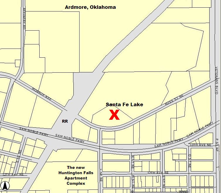
"Yes, we will miss that ole trestle on G street NE. We lived in the 600 block of G street almost now a 100 years. Walked under the trestle on the way to Mama and Papa Lloyd's at the Santa Fe Lake. Rode the Dinky across it on the way to Provence, to visit Aunt Ruth and Uncle Mack and our cousins there.
The Santa Fe Lake was near the refinery. There was a manned pump station there for the steam engines to fill with water. Our Dad had the lease from the railroad on the property after the Lloyd's passed away. When our Dad died in l964, we failed to renew the lease. Someone else leased the property from the railroad and blasted the dam on the small creek running through and drained the lake and used it for pasture. It had been quite a popular fishing place for people in that area and neighborhood. The Lloyds collected a small fee for fishing there, seems like maybe 10 cents. The Lloyds were like grandparents to us. They had five children. Two lived to adult hood. Harold, a son was in the Navy. He married a girl in California. He was killed in a hunting accident there, about 1950. They had three children. His wife remarried and her husband adopted the children. I have always wondered what happened to them and where they might be??? Going down highway 70 go under the underpass on the right are some government apartments and a day care I think as we have not lived there this is as I recall visiting Ardmore. Across from these apartments etc. is an old motel two or three of the individual units are still there. There is a street going thru before Pst as I remember. This street will take you over to the old highway 70 pavement that is still there......take a right and the depression on the left is where the lake was. After the tornado about 46 the Lloyd's garage was in the middle of the lake. Their house was destroyed and the neighbors and the members of the Calvary Presbyterian church on 3rd N.E. rebuilt it for them. We had Thanksgiving Dinner there that year. We had duck from the Lake. Light from kerosene lamps with wicks. The house is still there, having been updated and remodeled a number of years ago. Henry Lloyd (Papa) had worked for the railroad. As far as I can remember he had palsy. He was alert and sang for we children all the time. They had fallen on hard times as so many people of that era. Mama (Ella) Lloyd sold milk, butter, eggs and worked in homes of some of the people there in Ardmore. I can remember going to the Veterans home with her. It smelled like coffee. When I think of that home that is what I remember the smell of coffee. She was the one who introduced us to pickled chicken feet. So when visiting churches In Taiwan, a few years ago, that I relished to share this familiar delicacy with them was a happy, delightful surprise to the Saints there." fjsmathers@aol.com
http://www.oklahomahistory.net/ttphotos9a/SantaFeLake09a.jpg
Q. How did Provence, get its' name?
A. Provence. In Carter County, 6 miles east of Ardmore. A post office from January 4, 1895 to October 14, 1933. Named for George Provence, local merchant. -Oklahoma Place Names
George M. Provence 12 MAR 1860 - 14 MAR 1898 Buried in Provence Cemetery
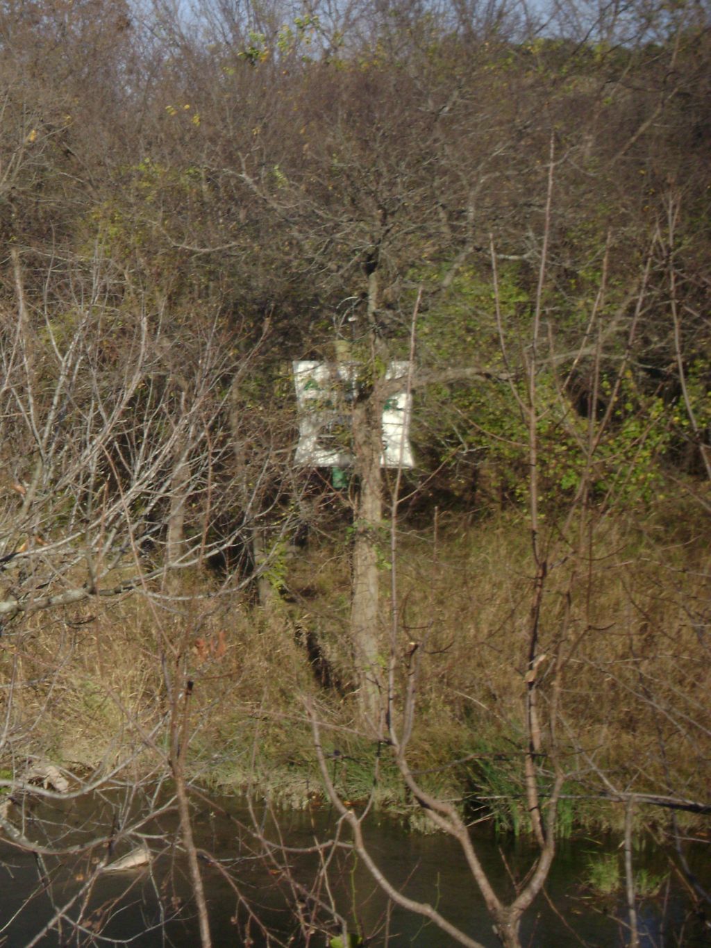
"Butch, while out riding my bicycle today I snapped a pic of the old Arnold Palmer Mini Golf place that used to be near Turner Falls. If you go towards Turner Falls from the Fried Pie shop, there is a pond on the north side of the road that used to say FEE FISHING and there is a cabin there which used to be an antique store at one time. It is directly across the road on the south side of Honey Creek. Its between the Pie shop and The Cliffs (aka Cedarvale). I have asked all around Davis and looked at the museum for photos of this place back when it was in operation. Does any T&T Readers have any of them have photos of it? You can still see the sign during this time of year as leaves begin to fall. Everyone in Davis remembers it being there and going there? but have yet to find any photos. Does anyone out there have a photo?" -Bryan Pullen
http://www.oklahomahistory.net/ttphotos9a/PalmerMiniGolf09a.jpg
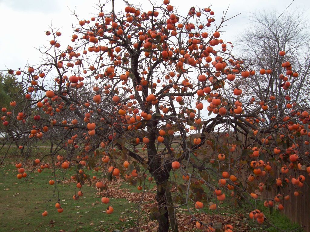
"Butch, Just now took this picture of my Persimmon Tree. I have a lot of onlookers. They aren't rip yet, they have to be frozen first. Sure brings in the wildlife too." -Sam Cottrell
http://www.oklahomahistory.net/ttphotos9a/PersimmonTreeCottrell9a.jpg
"Bengal Fire Ant Killer is fantastic!!! It worked when nothing else I tried did. Thanks for the tip. You might let your readers know that Gordon White Lumber on Broadway in Sulphur also carries it. I'm sure that their location in Davis probably has it as well." -Mary Lou Heltzel, Sulphur, OK
The Daily Ardmoreite
August 8, 1918
Ardmore On The Map
Route to Colorado Springs Provided Tourists
Ardmore is shown on a new automobile highway map which has just been issued and copyrighted by the Colorado Springs Chamber of Commerce and is available for all motor tourists of this locality. It is published in folder form, 17x22 inches in size.
The map is titled "Motor Routes to Colorado Springs and the Pikes Peak Region, America's Scenic Playground," and includes 'the touring territory that is adjacent to the Pikes Peak region and which furnishes the bulk of the travel to that resort'. It includes the Mississippi Valley and the Rocky Mountain region, taking in territory from Indianapolis, Nashville and Montgomery, Alabama, on the east to the Nevada-Utah line and the Grand Canyon of the Colorado and Arizona on the west, and from the Gulf of Mexico and the Mexican international boundary line on the south to Milwaukee and the Yellowstone park on the north. It includes, in considerable detail, the main highways in the following states:
Colorado, Wyoming, Utah, New Mexico, Texas, Oklahoma, Kansas, Nebraska, Iowa, Missouri, Arkansas, Louisiana, Illinois and Indiana.
Thirty-one different trails or highways are shown on the map. A plan of designating the various routes by initials makes it easy to locate and follow the route of any desired highway from practically every city within a radius of 1,200 miles to the east or south of Pikes Peak.
As reference for all motor routes and cities show the map is highly valuable. It was drawn from official information, much obtained from the five sociability and inspection tours made by the Colorado Springs Chamber or Commerce.
Supplies of the map have been sent to automobile clubs. Chambers of Commerce and road bureaus and copies can be obtained for free distribution at the Colorado Springs Chamber of Commerce.
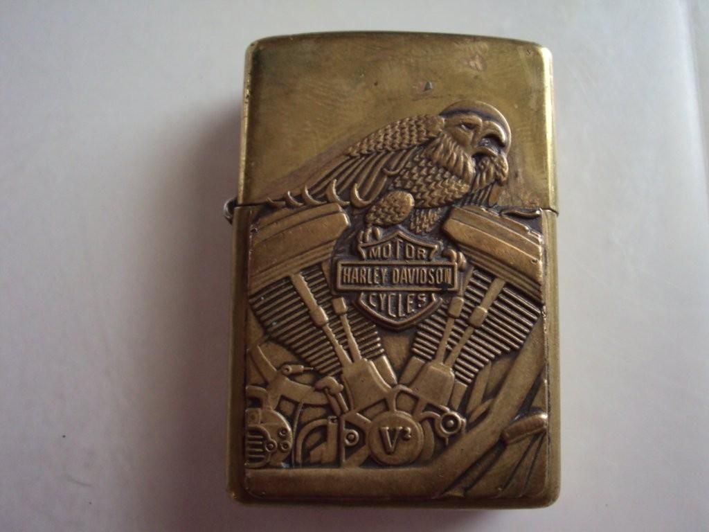
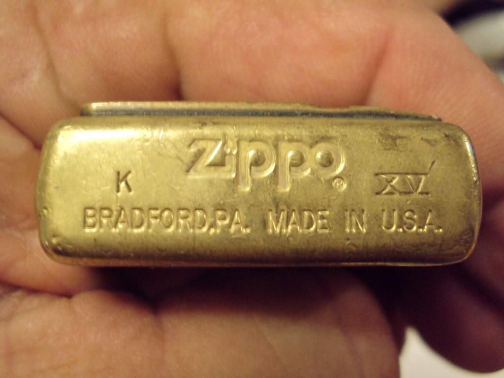
"Butch when my wife's uncle died, his brother gave my son a box of knives and he found this old lighter in the box, does anybody know how old this might be." -Doug Williams
http://www.oklahomahistory.net/ttphotos9a/HarleyLighter09a.jpg
http://www.oklahomahistory.net/ttphotos9a/HarleyLighter09b.jpg
"Underwater Video from Antelope Springs and Buffalo Springs: Butch, here are some video links from our visit to Chickasaw National Recreation Area in Sulphur, Oklahoma on November 3, 2009." -C. Dwane Stevens
Fall Foliage from Underwater:
http://www.youtube.com/watch?v=j9uWeN9_DjQ
Rising Gas Bubbles from Buffalo Springs:
http://www.youtube.com/watch?v=GAebI9QIZzg
Antelope Springs source water:
http://www.youtube.com/watch?v=gjpRdR6R0vU
Gas being released in Buffalo Springs:
http://www.youtube.com/watch?v=n7a9qUwHN_s
"Dear Butch, I don't know whether Hornespeed Flyer ever got off the ground, but according to The Mercantile Agency REFERENCE BOOK of April, 1924, there was no such business and apparently the propeller company was also gone. At that time there was one tire production company in Ardmore, the Paul Rubber Company.
Your mention of the turkey foot last week reminded me to send a photo I found of one of the turkey farms that was located on US 77 just south of town. This picture was taken in 1950.
Last week you also had a site for Beverly's Chicken-In-The-Rough. The Hill Top Cafe south of Ardmore used to be a Beverly's franchisee. The chicken was as wonderful along with hot biscuits and fresh cut french fries.
In the 60's and 70's I used to go to two of the Beverly's in Oklahoma City because they served donuts the size of a plate and they would cut them in half and butter them before putting them on the grill. Absolutely great along with a cup of coffee." -Monroe Cameron
"Last year or the year before you mentioned wanting some grapefruit from the Rio Grande Valley of Texas. They have the Texas Rio Star at the Farmers Market for a good price. This is the grapefruit that is the main one in the valley now and is considered to be the best. I lived there for 26 years before returning to Ardmore."
http://www.oklahomahistory.net/ttphotos9a/BricktownNearingCompletion1997a.jpg
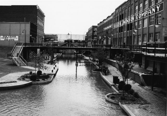
http://www.oklahomahistory.net/ttphotos9a/BricktownUnderConstruction1997a.jpg
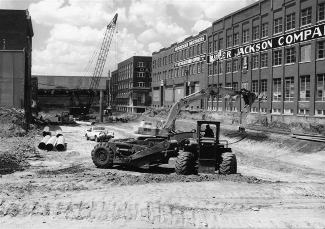
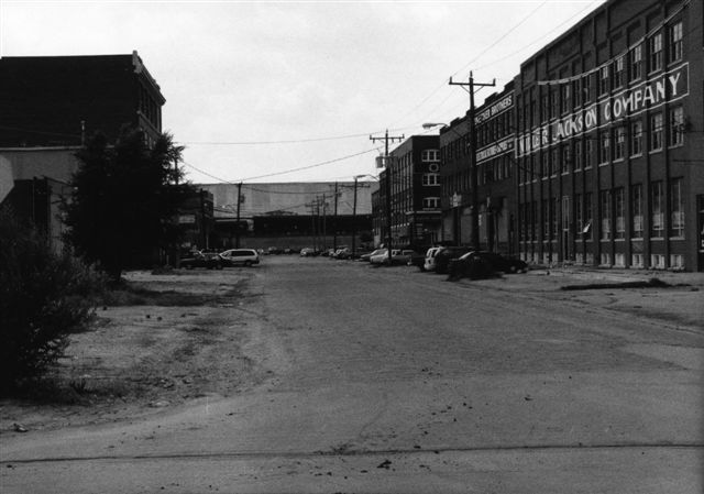
http://www.oklahomahistory.net/ttphotos9a/BrickTownBeforeConstruction1997a.jpg
http://www.oklahomahistory.net/ttphotos9a/BricktownUnderConstruction1997b.jpg
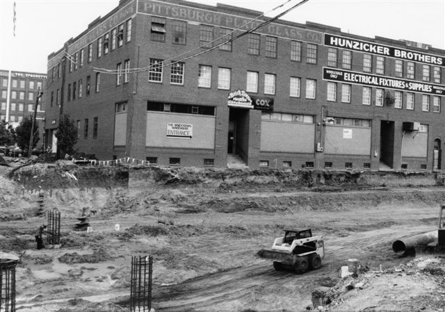
http://www.oklahomahistory.net/ttphotos9a/BricktownUnderConstruction1997c.jpg
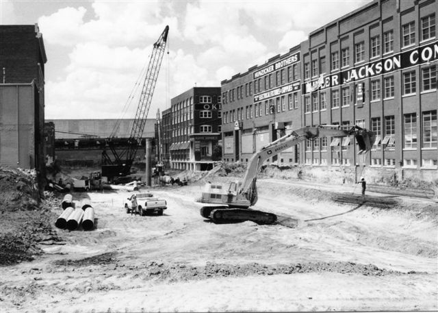
http://www.oklahomahistory.net/ttphotos9a/BricktownUnderConstruction1997d.jpg
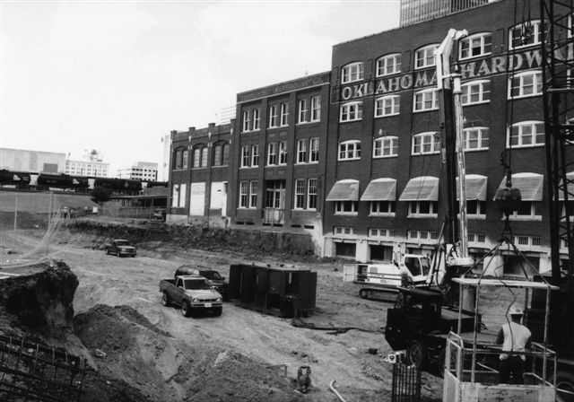
http://www.oklahomahistory.net/ttphotos9a/BrickTown1997a.jpg
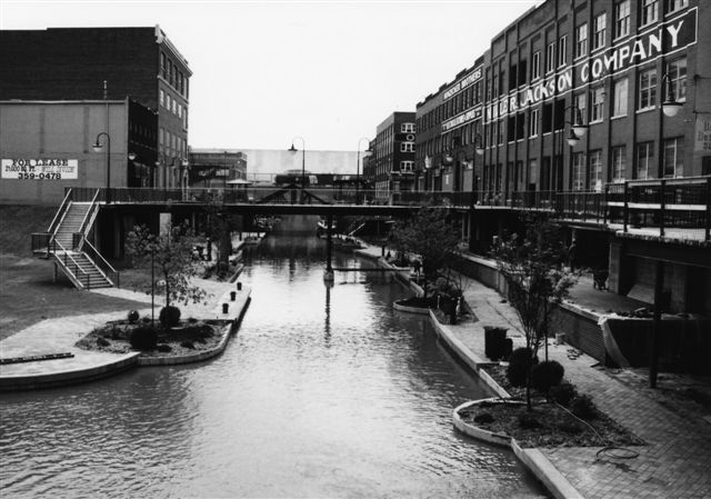
"In Love County, Nathan Banks had a grocery and Post Office at Bellville near the cotton gin. After many years he sold the store and it was continued by Marion Roberson, then Arthur Blankenship, then Jack Blankenship. The Post Office Window and mail boxes are in the Love County Historical Museum." -Gaye Dewbre, Courtney, Okla.
Q. Why did they decide to take the trestles down? -Paul T.
A. Around 9 years ago, my family and I caught an unauthorized salvage crew taking up the rail on the old trestle line in northeast Ardmore on a 4th of July weekend as we came into town for a visit with my folks.
Part of my work with North American Transportation Institute is pressing the seemingly entirely obvious case for the preservation and intelligent reuse of such assets.
I was fortunate that weekend to find the home telephone number of a BNSF Railway Company official in Topeka responsible for property disposition -- who assured me that, at that time, no permission had been given for destruction of the line.
We got the demolition stopped back then -- although a great deal of the rail had already been stripped off the line, along with the removal into a heap of switch stands and other appurtenances. Unfortunately, that particular heap was taken and sold for scrap by a local iron and metal operation -- also without authorization.
I was assured that the City of Ardmore or the local development authority, would take and preserve the property for future use. Unfortunately, what apparently inexplicably developed was a plan, not for use of the property as a rail line, but as a public "pedestrian trail."
I made what case I could for what I consider a far better idea: The historic, relatively lightweight rail from the line, itself, manufactured by Cambria, a steel mill gone by 1916 and located in Johnstown, Pennsylvania (there's that "Pennsylvania" connection, yet again...), should be taken up and relaid as an electric trolley line down Main Street via Ardmore Union Station (long known locally as "the Santa Fe Depot"). This, I believed then as now, would have sparked a strong revitalization in downtown Ardmore and begun a mobility revolution in the area.
Part two was to refit the former Frisco (also former Rock Island) rail line across the historic trestles with heavier, more modern rail as a commuter and freight line to the northeast to serve businesses such as Magcobar, the Agribusiness Store and OK Iron and Metal, as well as providing regular passenger access from the downtown station to and from The Noble Foundation and Southern Oklahoma Technology Center, and to the neighborhoods along the way.
It would have been a grand start for a return to a rail network radiating out of the historic downtown depot, giving Ardmoreites and eventually those in surrounding communities a low-cost alternative to "streets and highways only," and a fall-back position in the event of the return of high motor fuel prices or worse. There's also the matter of the need for our older and younger generations who cannot drive automobiles to have safe mobility -- of the sort that I think auto operators would find very attractive, as well.
In any case, I though that we had, at least, secured the future of the unique rail corridor.
Somewhere along the way, however, the plan for Ardmore government to take the rail line apparently failed -- as I discovered when I heard last week that BNSF was already at work destroying the line.
Even worse, it was entirely apparent from the broken debris of the trestle structure that it had been in extremely good condition for a property that had not been operated in a decade -- and could have been pressed into beneficial service at very reasonable cost. ("This is just a terrible shame," one of the salvage crewmen said, as we looked at the remains of tens-of-thousands of dollars worth of huge, coal-black creosote timbers that looked nearly like new.) The cost of replacing trestle and bridges, which had been there for over 100 years, would now be very daunting, I'm afraid -- but, perhaps, still possible.
I can't express my sorrow at the loss of this landmark asset, which predated statehood -- although I hope that the elevated grades might be saved for future consideration. I can only say that work on this idea is ongoing.
Folks - we just can't afford these kind of losses. Somehow, somewhere, we dropped the ball on this one.
-TOM ELMORE, North American Transportation Institute, www.advancedtransport.org
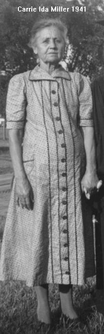
With the Fall weather here, I'm reminded of how my great grandmother would fire up her big iron kettle out back of her house in NE Ardmore and make lye soap. Granny Miller's lye soap was perfect. We used it year round when I was a wee teen and before.
Grandma's Lye Soap by Oklahoman Johnny Standley 1952
Do you remember grandma's lye
soap?
Good for everything in the home,
And the secret was in the scrubbing,
It wouldn't suds and couldn't foam.
Then let us sing right out of grandma's, of grandma's lye soap
Used for - for everything, everything on the place,
For pots and kettles, the dirty dishes, and for your hands and for your face.
Little Herman and brother Thurman
Had an aversion to washing their ears
Grandma scrubbed them with the lye soap.
And they haven't heard a word in years.
Then let us sing right out of grandma's, of grandma's lye soap.
Sing all out, all over the place.
The pots and kettles, the dirty dishes, and also hands and also face.
(clapping fades)
Well, let's sing what's left of the last verse.
Let's have a happy time, everyone.
The last verse, al-l-l-l together.
Ev-v-v-very one!
Mm-m-m-m. Thank you kindly, kindly,
M-m-mrs. O'Malley, out in the valley,
Suffered from Ulcers, I understand.
She swallowed a cake of grandma's lye soap,
Has the cleanest ulcers in the land.
Then let us sing right out of grandma's, of grandma's lye soap.
Sing right out. All over the place.
The pots and - the pots and pans, oh dirty dishes,
And the hands.
http://www.youtube.com/watch?v=xr_XQjBEgzk
See everyone next week!
Butch and Jill Bridges
PO Box 2
Lone Grove, Oklahoma 73443

Save on long distance calls, just a couple cents a
minute!
http://www.CheapLongDistance.org
Oklahoma Bells:
http://www.OklahomaHistory.net/bellpage.html
American Flyers Memorial Fund - Administration Webpage
http://www.OklahomaHistory.net/crash66.html
Official American Flyers Memorial Website
http://www.brightok.net/~wwwafm
Ardmore Army Air Field/Ardmore Air Force Base Website
http://www.brightok.net/~gsimmons
Mirror Site of the Ardmore Army Air Field/Ardmore Air Force Website
http://www.OklahomaHistory.net/airbase/
Carter county schools, past and present
http://community.webshots.com/user/oklahomahistory
Carter County Government Website
http://www.brightok.net/cartercounty/
All previous issues of This & That can be found on my Website.
Feel free to forward this free newsletter. Mailouts: over 1,600.
To be removed from my T&T mailings, just send me an email.
I do not sell, trade or give my mailing list to anyone for any reason.